TENZYE | Agentic Tender Intelligence Platform by ELMNTX
AI Road Inspection Platform · Trusted by 200+ Government Agencies

ROADBOT: Where AI
Meets the Road

An end-to-end AI-powered platform that automates road inspection, condition assessment, and asset management — turning sensor data into actionable intelligence for governments and municipalities worldwide.

95%+ Defect Accuracy 90% Faster Inspections 40% Cost Reduction GDPR-Ready
90%
Faster Inspections
vs. manual methods
95%+
Defect Accuracy
Validated by LiDAR + AI
40%
Cost Reduction
Operational savings
200+
Government Agencies
Globally trusted
30+ types
Defect Types Detected
mm accuracy
Measurement Precision
12–18 mo
ROI Payback Period
30 days
to First Data Collection
GDPR
Privacy by Design
The Challenge

When Infrastructure Management
Hits a Dead End

Keeping roads safe and resilient should be data-driven, not guesswork. Yet today's manual, fragmented approaches leave agencies navigating in the dark — risking public safety, wasting taxpayer money, and falling behind on essential maintenance.

"We saw a broken system: roads managed reactively, with fading paint and rising public frustration. Manual inspections were guesswork. Budgets were black boxes. Data was dusty, disconnected, and delayed."

📋

Incomplete Asset Registers

Missing or outdated inventories lead to blind spots in planning and liability. You can't manage what you can't see.

🕳️

Delayed Defect Detection

Potholes and cracks are found only after damage occurs — or is reported by the public. Reactive repair costs 4–5× more than preventive action.

🗺️

No Live Network View

Decisions are based on outdated snapshots, not real-time system-wide condition data. Strategic planning becomes guesswork.

💸

Unsustainable Costs

Manual inspections consume over 70% of assessment budgets in labor and logistics. There's no data-driven return on that investment.

🔄

Disconnected Workflows

Silos between planning, finance, and maintenance create friction and waste. Defects detected never become work orders without manual intervention.

📉

Eroding Public Trust

Reactive repairs and declining road quality undermine citizen confidence and safety. Poor roads cost governments far more in public perception than money.

The ROADBOT Solution

A Fully Automated System from
Data Collection to Actionable Output

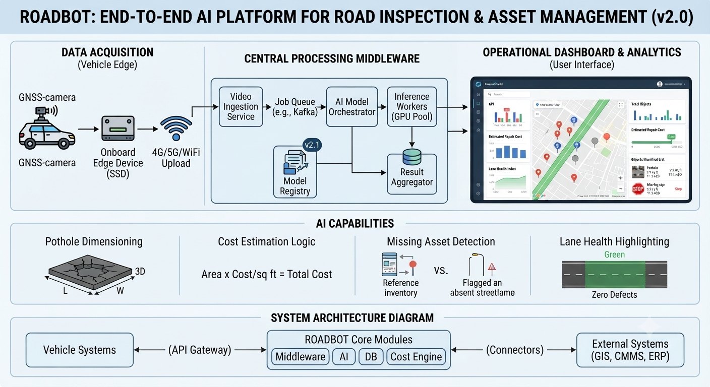
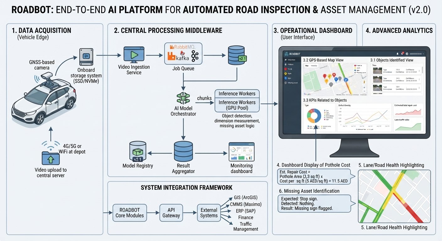
Smart inspection vehicles combined with a cloud-based AI analytics platform — transforming road surveys from days of manual effort to hours of automated intelligence.

Step 01
🚗
Data Collection
Smart inspection vehicles equipped with LiDAR, cameras, GPS, and edge AI collect road data in real time — at normal traffic speed, no lane closures.
Step 02
🤖
AI Analysis
Machine learning models detect defects, measure dimensions, and tag assets with millimeter accuracy — processing thousands of km in hours.
Step 03
☁️
Cloud Processing
Data is fused, analyzed, and visualized in a centralized dashboard — condition indices, asset registers, and priority heat maps updated live.
Step 04
📊
Actionable Outputs
Maintenance alerts, rideability indices, work orders, and compliance reports delivered directly to relevant authorities and integrated systems.
Key Features

The Intelligence
Behind the Platform

ROADBOT combines cutting-edge AI with purpose-built technology to transform road management. Each feature addresses a specific challenge with precision, automation, and actionable insight.

30+ defect types — potholes, cracks, rutting, edge breaks
Millimeter-level measurement precision
Survey at normal traffic speed — no lane closures
GDPR-compliant privacy-by-design, auto face/plate blurring
Open APIs for CMMS, GIS, ERP integration
On-premise or sovereign cloud deployment available
🔍
Automated Defect Detection

Proprietary algorithms automatically identify, measure, and classify 30+ defect types — potholes, cracks, rutting, and edge breaks — with millimeter accuracy. Process thousands of kilometres in hours, not weeks.

30+ defect typesmm accuracy95%+ precision
🏷️
Smart Asset Inventory & Tagging

Automatically detect, classify, and geolocate every road asset — signboards, guardrails, streetlights, and manhole covers. Maintain a live, accurate digital twin of your entire network for planning and compliance.

Digital twinLive registerGIS-ready
🗺️
3D Digital Mapping & Point Clouds

Generate high-definition 3D reconstructions and point clouds of road geometry. Perfect for design verification, volumetric analysis, and future planning with centimetre-level precision.

LiDAR point cloudsHD 3D modelscm precision
🔒
Privacy-by-Design Processing

Built-in AI immediately blurs faces, licence plates, and sensitive identifiers in all public-facing imagery. Ensure complete GDPR and local privacy regulation compliance without manual intervention.

GDPR-compliantAuto-blurringUAE regulations
📡
Real-Time Command Dashboard

Monitor inspection progress, condition indices, and asset health through a unified, customisable dashboard. Watch data populate live as vehicles survey your network, with automated alerts for critical defects.

Live data streamsCustom alertsOne-click reports
🔗
Seamless System Integration

Open APIs and pre-built connectors integrate with your existing CMMS, GIS, ERP, and financial systems. Eliminate data silos and enable seamless workflows from detection to work order to payment.

Open APICMMS · GIS · ERPSAP Ariba
Use Cases

Real Problems, Intelligent Solutions

ROADBOT delivers actionable intelligence where it matters most — transforming workflows, budgets, and outcomes for every stakeholder in the infrastructure ecosystem.

🏛️

Government Road Authorities

Maintain comprehensive asset registers, monitor network health across thousands of kilometres, and plan maintenance budgets with confidence backed by accurate condition data.

🏙️

Municipalities & City Councils

Prioritize repairs based on accurate, up-to-date condition data rather than public complaints. Justify budget decisions with real evidence and demonstrate ROI to elected officials.

🏗️

Infrastructure Contractors

Validate work quality objectively, track project progress, and deliver digital-format condition reports that satisfy government contract requirements and reduce disputes.

📐

Urban Planners

Use high-definition 3D models and GIS-integrated data for future road designs, capacity planning, and environmental impact assessments with centimetre-level accuracy.

Results That Speak

Tangible Outcomes That Redefine
Infrastructure Management

Beyond promises — measurable outcomes that redefine efficiency, accuracy, and value in road infrastructure management worldwide.

90%

Faster Inspections

Survey entire networks at traffic speed. What took weeks of manual effort now takes days — or hours for urban areas.

95%+

Defect Accuracy

AI models validated against LiDAR and image data deliver millimetre-level measurement precision on 30+ defect types.

40%

Cost Reduction

Eliminate labour-heavy manual surveys. Shift budget from reactive emergency repairs to planned preventive maintenance.

12–18mo

ROI Payback

Clients typically realize full platform return on investment within 12–18 months through cost savings and efficiency gains.

Case Study · Public Services Department, Ras Al Khaimah

"ROADBOT enabled Ras Al Khaimah PSD to shift from reactive to proactive road management, reducing inspection time by 85% while improving data accuracy."

Public Services Department, RAK — UAE
85%
Inspection Time Reduction
Modular & Scalable

Build Your Perfect Solution

ROADBOT grows with you. Start with what you need today, and seamlessly expand as your needs evolve — no rip-and-replace, no dead-end investments. Annual SaaS subscription, scaled to network size.

ESSENTIAL

Intelligent Inspection & Core Reporting

Perfect for agencies beginning digital transformation

Automate defect detection, generate instant reports, and establish your first live road health dashboard.

Automated defect detection
Live road health dashboard
Instant PDF reports
Deploy in 30 days
Get Started →
ENTERPRISE

Fully Customised, Sovereign Deployment

Strategic infrastructure management at scale

Custom AI model training, on-premise or private cloud deployment, dedicated support, and multi-agency coordination.

Everything in Professional
Custom AI model training
On-premise / sovereign cloud
Dedicated support team
Multi-agency coordination
Contact Sales →
FEDERATION

Cross-Jurisdiction & National Infrastructure

Entire regions or nations

Coordinate an entire region. Standardized reporting across agencies, federated AI governance, and inter-agency workflow automation.

Everything in Enterprise
Federated AI governance
Cross-agency data sharing
National oversight dashboards
Talk to Us →
Voices from the Field

Trusted by Infrastructure Leaders

Real outcomes from government agencies, municipalities, and road authorities who have made the shift from reactive to proactive road management.

★★★★★4.8
"Manual inspections were creating a huge backlog. ROADBOT enabled us to survey our entire municipal road network in weeks, not months. The accuracy of the asset register alone has transformed our planning and budget justifications."
Rajesh Verma
Municipal Commissioner, Nagpur
★★★★★4.8
"The AI's accuracy in detecting early-stage cracking helps us act before damage escalates. Public complaints on road conditions have fallen by over 60%."
Anjali Deshpande
City Manager
★★★★★4.8
"Managing a vast state highway network required a single source of truth. ROADBOT gave us a live command dashboard with real-time condition indexes, transforming how we allocate funds and resources across districts."
S. Ramesh
Principal Secretary, TN PWD
FAQ

Frequently Asked Questions

Clear answers to the most common questions about implementing and scaling ROADBOT for your infrastructure network.

Start in 30 Days

Get your first live road condition data within a month. Talk to our public sector specialists to see how ROADBOT can modernize your network management.

Request a Demo
How quickly can ROADBOT be deployed?
+
Most agencies begin collecting data within 30 days of contract signing. The Essential platform requires no hardware installation — just sensor integration on your inspection vehicles. Professional and Enterprise tiers typically deploy within 60–90 days, including staff training and system integration.
What is the pricing model?
+
We operate on a transparent annual SaaS subscription, scaled to your network size and platform tier — eliminating large upfront capital expenditure. Contact our sales team for a custom quote based on your network kilometres and required modules.
How accurate is the AI detection?
+
Our models deliver over 95% accuracy in defect identification and millimetre-level measurement precision, validated against LiDAR and high-resolution image data across diverse road types and conditions.
How is data privacy handled?
+
Privacy is built-in by design. AI automatically blurs faces and licence plates in all captured imagery before any human review. We comply with GDPR, UAE data regulations, and offer sovereign on-premise deployment for agencies requiring complete data residency.
Does it integrate with our current systems?
+
Yes. ROADBOT offers open APIs and pre-built connectors for seamless, secure integration with existing CMMS, GIS, ERP, and asset management platforms. Our team handles the integration setup as part of onboarding.
What ROI can we expect?
+
Clients achieve up to 90% faster inspections and 40% lower operational costs. Agencies typically realize full platform ROI within 12–18 months — primarily through reduced survey labour, better-timed preventive maintenance, and fewer costly emergency repairs.

Start Your Intelligent
Road Transformation

Turn road data into decisive action. Connect with our public sector specialists to see how ROADBOT can modernize your network management.

Trusted by 200+ Government Agencies · UAE · India · Global